
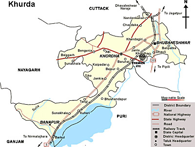
Khordha District is an administrative district of Orissa. Khordha is the headquarter town of the district and is 20 kms from the capital city of Bhubaneswar. Khordha District is located between 19 degree 40 minutes to 20 degree 25 minutes north latitude and 24 degree 55 minutes to 36 degree 5 minutes east longitude. Khordha District is bounded by Cuttack District in the north and north-east, by Nayagarh District in the west, by Puri District in the south and by Ganjam District in the south west. Total geographical area of Khordha District is 2887.50 sq kms. Rural area is near about 2642.16 sq kms and urban area is 245.3416 sq kms.
History of Khordha District
History of Khordha District
Khordha District came into being on 1st of April, 1993 by dividing erstwhile Puri District which after division became Puri, Khurda and Nayagarh. Later on in the year 2000 the name of the district was changed to Khordha. The present Khurda area was once heavily populated by the Savaras. Khurda came into prominence when the first Rajas of Khordha dynasty, Ramachandra Deva, made it the capital of his kingdom during the end of 16th century A.D. The Bhoi kings lived in a part of the foot of the Barunai Hill, about 1.6 km to the south of the town. History states that the region of Khordha District suffered repeated onslaughts from Muslim and Maratha invaders.
Geography of Khordha District
Khordha District on the basis of soil, climate topography, geo-hydrology and other resources is divided into two sub-regions consisting of several blocks. The first one is Deltaic Alluvium Sub-regions and three blocks namely, Balipatna, Balianta and Chilika come under Deltaic Alluvium sub-region. Second one is the Laterite sub-regions and the remaining seven blocks namely Bhubaneswar, Begunia, Bolagarh, Jatni, Khurda, Banpur and Tangi come under this sub-region. The main rivers flowing through the district are River Kuakhai (originating as a branch of Mahanadi River), River Bhargavi, Budunai River, River Daya, Kusabhadra River, Malaguni River, Rana River and Kusumi River.
Demography of Khordha District
Total population of Khordha District as per 2001 Census is 18,77,395, out of which male population is 9,86,886 and female population is 8,90,509. Schedule Caste population of the district is 2, 54,251 and Schedule Tribe of the district is 97,186.
Administration of Khordha District
Administration of Khordha District comprises two sub divisions namely Khordha and Bhubaneswar. There are ten tehsils in Khordha District and these are Balianta, Balipatna, Banpur, Begunia, Bhubaneswar, Bolagarh, Chilka, Jatni, Khordha and Tangi. It also comprises ten development blocks. Administration of Khordha district includes two Notified Area Councils (NAC) and two Municipalities. Khordha District has one Municipal Corporation, two Parliamentary Constituencies and eight Assembly Constituencies.
Khordha District is an important centre of handloom industry of the state and stone carving is a major handicraft of the district.


0 comments:
Post a Comment